The Moss Canals are a group of former navigations serving Chat Moss, off the Bridgewater Canal between Worsley and Boothstown.
When the Bridgewater Canal was first proposed, it was intended to have one part running south-eastwards from Worsley to Salford, with another route going south-westwards to meet the Mersey and Irwell Navigation at Hollin Ferry.
Work on the Hollin Ferry route began in 1759, heading due west for a mile, then turning sharply to the south at Keeper's Turn. It was planned to follow alongside the Moss Brook and Glaze Brook, keeping at the 82 ft contour for as far as possible, then with several locks being needed to take it down to the river level. This route was intended for carrying coal from Worsley to the developing industries of the Warrington area.
However, possibly because of the success of the Sankey Canal in supplying Warrington, this route was abandoned in 1760, after 2.5 miles had been constructed to Botany Bay Wood, at a point south of Malkins Wood Farm. At the same time, the original route to Salford was abandoned at Patricroft and a new line taken, crossing the Irwell at Barton, and heading into Manchester on the south side of the Irwell.
The canal to Botany Bay Wood remained in use, however, carrying spoil from canal construction and waste from the mines to be dumped on Chat Moss for the purpose of land improvement.
Around 1785, a second short canal was built onto Chat Moss, running southwards from a junction at Bittern Pits Wood, around half-way between Worsley and Keeper's Turn. There was a boat house on this canal, not far from the junction with the main line. This second canal had a short branch running south-eastwards. These canals were supplemented by tramroads to help disperse the waste over a wider area.
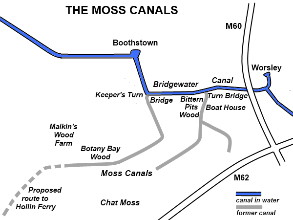
Diagram of Moss Canals.
In 1791 the Lancaster Canal Company proposed a link from their canal at New Springs above Wigan to the Bridgewater Canal at Worsley. The Bridgewater Canal Company countered with a plan to build a level canal to Leigh where it would later meet a branch of the Leeds and Liverpool Canal from the centre of Wigan. This Leigh extension opened in 1799, leaving the Hollin Ferry route at Keeper's Turn.
By 1848 the Ordnance Survey map shows that the canal from Keeper's Turn to Botany Bay Wood had been closed and no longer in water, although the 1893 map still shows the line of the dry canal. The northern half of the second canal at Bittern Pits was still shown as being in water right up to the 1909 map, but, by 1928, while some of the branch is in water, the first section from the junction with the main line is shown as being dry, so that the canal was no longer navigable. By 1971, none of the canal route is shown to be in water.
However, as can be seen in the photos below, the line of the canal is still apparent as a depression running through the woods and some sections of stone wash wall are visible as testimony to these forgotten waterways.
There is an old photo on this web page showing the swing bridge at the junction of the Moss Canal at Bittern Pits. The information about a link to Salteye Brook is not correct but the photo is worth viewing. The boat house is out of sight a short distance behind the photographer.
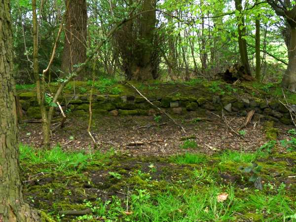
Remnants of the stone wash wall of the canal in Bittern Pits Wood. Photo: Jonathan Aylen
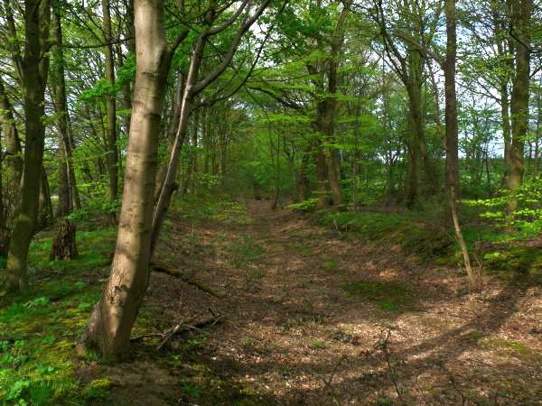
The route of the canal through Bittern Pits Wood, visible as a depression. Photo: Jonathan Aylen