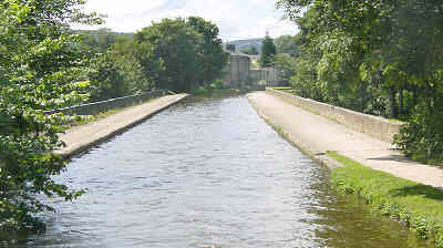
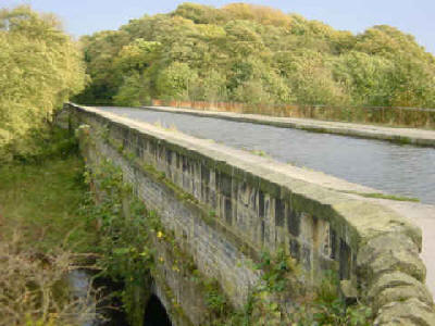
Dowley Gap Aqueduct repairs
November 2005
The Leeds and Liverpool Canal will be closed between November 2005 and March 2006 at Dowley Gap, south-east of Bingley.
On November 14th, major repair work began on the Dowley Gap Aqueduct across the River Aire - a Grade 2 listed structure. The canal and towpath are closed. The alternative route for pedestrians is alongside the River Aire. The footpath adjacent to the aqueduct will also be closed.
British Waterways maintenance staff and contractors will be strengthening the structure, lining the channel, carrying out urgent repairs and removing overgrown vegetation to improve and safeguard the aqueduct for the future. The work will prevent water escaping through leaks in the canal bed that have been causing damage to the structure's stonework. The work will also address the movement and bulging of the aqueduct's spandrel walls as well as circumferential cracks and deep open joints in the masonry which have opened up on each span.
Because of the isolated location of the aqueduct, access to the site is difficult. Where possible materials will be delivered by water. In order to prevent future deterioration of the structure vegetation around the aqueduct will be cleared. This is necessary to prevent seeds being dropped onto the aqueduct and the risks of root growth undermining its foundations.
This is part of a programme by BW to repair 80 "at risk" listed properties in their ownership by 2008.
Laurence Morgan , BW's Yorkshire manager, said: "This is part of a backlog of work we need to carry out during our winter maintenance programme both to preserve this important historical structure and so that the canal can remain open. We are working with Bradford Council to put up diversionary signs while work is being carried out and we hope that people will bear with us while we carry out the work which we are aiming to complete by February."
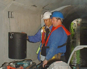
Fish and crayfish were rescued from the canal before it was drained. The scheme includes the conservation of protected bats. BW's bat specialist has identified bat roosts in the arch soffits and will ensure these are protected throughout the works. Janet Baverstock of British Waterways, Yorkshire, said: "We give special consideration to the canal's unique environment and wildlife. It is important to ensure that rare and protected species that live in or beside the waterway remain undisturbed or, if necessary, they are removed safely to temporary homes.
The work will cost around £650,000. The canal at Dowley Gap is due to re-open by 31st March 2006.
Wildlife on the Waterways
November 2005

A recent survey conducted by British Waterways throughout the country has revealed some surprisingly rare wildlife on our waterways.
Hundreds of visitors to the canal and river network recorded more than 3,700 sightings of 60 different species, including some of the UK's rarest wildlife, such as kingfishers and the endangered water voles and otters.
The top five species to see on Britain's waterways are mallards, swans, moorhens, herons and coots, although as many as one in 20 people observed kingfishers, water voles, bats and grass snakes. Sightings of non-native species included terrapins, mink and Chinese mitten crabs. There was concern that one in twenty people reported seeing mink on the waterways.
Some more unusual creatures were spotted, including seals, dolphins and porpoises on Scottish waterways; osprey by the Oxford Canal and a small crocodile on the Cotswold Canal! The information will be incorporated into the national species database, which records biodiversity on the inland waterways.
Records were submitted from all parts of the region's waterways, from the tranquil waters of the Huddersfield Narrow Canal, to the Rochdale Canal in the heart of Manchester.
Chris John, British Waterways' ecologist, commented that some amazing wildlife has been spotted on Northern England's waterways and that this should encourage more people to visit our canals and rivers. "Canals and rivers are a haven for wildlife and provide vital green corridors that connect the countryside with the hearts of our towns and cities. Recording common, rare and non-native species will hep us to enhance the environment and maintain waterways that are rich in wildlife for all."
Photo: Swans and cygnets. (Photo courtesy of British Waterways)
Dredge Pledge
October 2005
Waterways in Yorkshire are to benefit from what British Waterways has dubbed its "Dredge Pledge". Following its "Veg Pledge", BW hopes that its latest programme will bring "significant improvements" to boaters' experiences. Yorkshire's dredging budget for this year will be £700,000 - treble last year's figure. Channels will be dredged to their original profiles where possible, with aquatic plant margins being retained at the edges where this is appropriate.
Work due to be carried out shortly include the eastern end of the Leeds and Liverpool Canal, where access to visitor moorings in popular locations will be improved, and spot dredging on the Sheffield and South Yorkshire Navigation. BW's Hydro team will use a new technique which will plot sedimentation, helping to target future dredging needs.
British Waterways Yorkshire's general manager, Laurence Morgan, described the increased dredging as "an investment in the future of the waterways, particularly as changes to waste management legislation are increasing the future cost of dredging works."
Salford Quays and Worsley Village Heritage Trails
October 2005
In October 2005, Salford City Council has produced a series of maps and trail booklets to launch its industrial heritage campaign, which celebrates the area's proud history.
These maps and self-guided walk booklets aim to make it easy to explore the city's industrial past. The range of walks includes:
Salford Quays - detailing how this area has been transformed from Manchester Docks to the modern commercial and residential waterfront development. The guide points out sculptures and other features to look out for, gives the stories behind bridges and buildings and explains the origins of names.
and:
Worsley Village -"birthplace of the transport revolution". The trail takes you around the village, explaining the stories behind the Alphabet Bridge, the church clock that strikes thirteen and various buildings around the green and canal. Special mention is made of the Duke of Bridgewater's mines and underground canal.

Two of the Salford Heritage Trail booklets.
The maps are £1 each and the trail guides are £1.50 each. Details of how to get them are on a website: http://www.visitsalford.info/industrialheritage
For photos of Salford Quays, click here.
For photos of Worsley Village, click here.
External Link:
"Visit Salford" website
Waterfront Quarter planned for Huddersfield
21st October 2005
An exciting new "Waterfront Quarter" could be built alongside the Huddersfield Narrow Canal near the centre of Huddersfield!
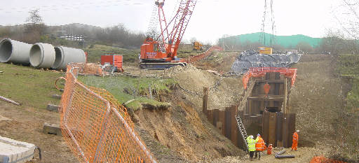
Proposals have been made which involve a twelve acre site lying in a triangle between Manchester Road, Chapel Hill and the River Colne immediately to the south of the town centre. The site is alongside the Huddersfield Narrow Canal between Locks 2e and 3e - a section which was re-opened to navigation in May 2001.

An initial artist's impression of part of the Huddersfield Waterfront development. Picture courtesy of Ramsden and Colne Developments.
The £200 million scheme would see the site, currently occupied by Sellers Engineering and West Riding House, transformed into a mixed development of waterside café bars and restaurants, offices, 500 apartments and a hotel.
The canal currently runs under the site through a tunnel, which was constructed in 2001 at a cost of around £4 million. Photos showing the construction of this tunnel can be seen here. The tunnel would be opened up so that the canal forms a feature of the development. The centrepiece would be a public square, where the canal would be crossed by a strikingly designed bridge, which would be supported by cables attached to a giant spike.
The scheme would include a riverside walk which would allow walkers on the towpath to continue through to Chapel Hill. The towpath currently comes to a dead end at Lock 3e, with walkers needing to take a detour from Lock 4e (see this page for details of current route).
Initial proposals were made earlier in the year and a core team has been working with Kirklees Council to allay any concerns over traffic and environment issues. An outline planning application will be submitted to Kirklees Council by the end of 2005. If the proposals are approved, work could begin on the site in 2007.
Update: A revised version of this scheme gets the go-ahead - click for more.
External Link:
Ramsden and Colne Developments
Going Batty on the Huddersfield Canal!
October 2005
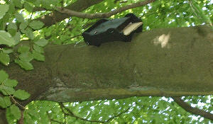
New homes have being provided for the Daubentons Bat on the Huddersfield Narrow Canal in Uppermill!
This was carried out by the Greater Manchester Bat Group and British Waterways with the support of The Waterways Trust.
The Daubenton's Bat is becoming rare in the area due to a lack of roosting sites. As part of the recovery programme, twenty new bat boxes will be installed along the canal for them to roost in.
Chris John, Ecologist for British Waterways, said: "This is a great contribution to bat conservation, we hope to see many more bats along the canal over the coming years."
Jim Taylor of the Greater Manchester Bat Group said: "The bat group looks forward to undertaking the monitoring of the project and intent to undertake a number of public "bat walks" in the coming year." Anyone interested in joining the group can contact him on 01706 665554."
Daubenton's Bat is a small species, with a pinkish-brown face. The fur on their upper-parts is dark grey/brown and the under-parts silvery grey. The wings and tail membrane are dark brown. They have large furry feet, which they use to grab prey from the surface of water. They hunt over open water such as canals
Photos, right: Bat boxes in a tree and under a canal bridge, courtesy of British Waterways.
Photos of the bat and more information can be found at this website or this one.
Bridgewater Canal Sluice Failure Drains Canal
Updated 11th July 2005
The Bridgewater Canal has been re-opened after the closure in the Manchester area. The canal is now open between Castlefield, Sale, Preston Brook and Runcorn. Water levels are down by as much as 14 inches and boaters are being asked to proceed with care to avoid grounding. Boaters will now be able to navigate the Cheshire Ring again.
However, due to differing water levels on the Leigh Branch, the branch will remain closed at Barton Aqueduct for at least another week (until around 18th July). Contact the Bridgewater Canal office on 0161 629 8266 for up-to-date information or check their website www.bridgewatercanal.co.uk

Stranded narrowboats sit high and dry in Castlefield Basin.

The restaurant boat LS Lowry and narrowboats are left high and dry.
The Bridgewater Canal had been closed in the Manchester area following a sluice gate failure at Castlefield in Manchester. The canal was closed between Sale, Barton and Manchester.
The closure of this section of the Bridgewater Canal affected boaters cruising the Cheshire Ring, as well as those heading to or from the Leeds and Liverpool Canal at Wigan. It took around a week for the levels to come back up to a navigable level once the sluice culvert had been sealed.
Boaters moored on the canal noticed the level droppingn the night of Sunday 3rd July and contacted the Manchester Ship Canal Company, which owns the Bridgewater Canal. Ground staff quickly put in stop planks at Sale and closed the swing aqueduct at Barton. Eight miles of canal in Manchester became almost completely drained, however, while the rest of the Bridgewater Canal was noticeably down.
Nine visiting boats were left high and dry by the escape of water in addition to the boats moored long-term in the Potato Wharf area of Castlefield.
Boaters remained cheerful about their situation and were full of praise for the Manchester Ship Canal Company staff, who had been doing their best to offset the inconvenience by bringing water, collecting rubbish, lending generators and offering to fetch shopping. Arrangements were made for the stranded boaters to use showers at a nearby hotel. The crew of a hire boat were transferred to another boat elsewhere so that they could continue their holiday.

An attempt to block the entrance to the failed sluice. The sluice gate's position is under the hut. The water level has risen two feet by the time this picture was taken.

On the opposite bank, a large crane has been brought in to lower bags of sand into position.

The problem was caused by the failure of a wooden sluice gate which is used to regulate the flow of water through Castlefield when the River Medlock is in flood. Water from the Medlock normally bypasses the canal at Castlefield by means of a culvert but, when the river is in flood, the culvert cannot cope and water comes into Castlefield Basin, which was the original course of the river. The sluice which has failed allows excess water to flow directly back into the River Medlock downstream of Castlefield.
MSC staff believe that the wooden sluice gate just gave way even though it only had the normal weight of water against it. There is no provision for stop planks to be put across the entrance to the sluice culvert so staff had to improvise a dam in an attempt to stem the flow. Stop planks were placed across the entrance and huge bags of sand were lowered into the canal against them to hold them in place and seal the entrance, using a crane on the opposite bank.
The first attempt seemed to be working and the water level started rising, but then the pressure of water caused the large builders' sand bags to disintegrate and 20 tonnes of sand from the bags were sucked through sluice culvert and into the River Medlock, draining the canal again. In a second attempt, sealed sandbags were placed inside the larger bags, which were then lowered into place across the stop planks.
The Environment Agency has sent in teams to assist the MSC staff because of concerns for wildlife along the eight miles of canal affected.
Honour for North West BW man!
7th July 2005
Waterway maintenance supervisor Jimmy Swindells has been awarded an MBE in the 2005 Queen's birthday honours list.
Mr Swindells has worked for BW for 28 years and currently looks after the Ashton, Rochdale and Manchester Bolton and Bury Canals.
Jimmy said: "I would like to say a big thank you to all the people I work with and have worked with in the past. Gaining this is not just about me but about all the people I have worked with and learnt from coming up through the ranks."
BW General Manager Adrian Sains said: "Jimmy is a real credit to British Waterways. His enthusiasm and knowledge of the waterways are unsurpassed and he is a well known face along the Rochdale and Ashton Canals. He is always willing to go that extra mile to ensure that our customer's expectations are met and exceeded!"
Jimmy has been with British Waterways since 1977 and has worked on the Ashton Canal, the Manchester Bolton and Bury Canal and the Huddersfield Narrow Canal. Jimmy then became a Lock Keeper and Reservoir Attendant for eight years at Barrowford Locks. Working his way up from Foreman, Jimmy became a Waterways Supervisor at Burnley and then took on responsibility for Wigan and Liverpool. There then followed a short spell in Marketing as Community Development Officer for the Leeds & Liverpool Canal before moving to back to Manchester as Waterway Supervisor for the restoration of Rochdale Canal and the Manchester, Bolton and Bury Canal.
Photo: Jimmy Swindells at Slattocks locks (BW).
Pontoon towpath for Rochdale Canal tunnel
11th May 2005
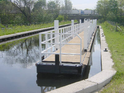
Towpath users on the Rochdale Canal will be pleased to know that they will be able to walk through the tunnel under the M62 rather than having to make the detour along the A664 Manchester Road.
A special floating pontoon has been constructed which can be fixed in place under the motorway so that towpath users can pass through. If a wide beam boat need to use the tunnel, BW staff will come out and move the pontoon into the nearby lay-by.
Wide beam boat users should phone BW to arrange passage.
Narrowboats will be able to fit through the tunnel alongside the pontoon and do not need to contact BW.
Photo: The towpath pontoon awaiting instalation in the motorway tunnel.
Rochdale Canal Arm Re-appears Briefly!
April 2005
A former short arm of the Rochdale Canal has made a brief re-appearance!
The arm, which served timber wharves just off the Rochdale Canal, near its junction with the Ashton Canal in Manchester, had been in-filled for many years.
Civil Engineering company Clugston Construction are to build a multi-storey car park on the site but, before they could begin, they had to remove the previous contaminated in-fill from the arm and replace it with "clean" in-fill.
For a few days in April 2005, the arm was clearly visible before being buried once again. It is understood that the brick wash walls with their stone capping will be left intact when the arm is filled in.
Photo, right: The exposed arm, looking south from the Rochdale Canal.
Photo, below: The exposed arm, looking north towards the Rochdale Canal.
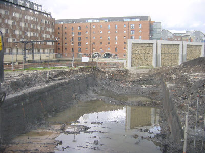
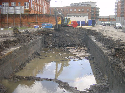
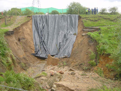
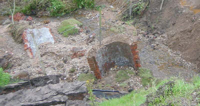
Major Breach at Irk Aqueduct
April 2005
A major breach occurred next to the Irk Aqueduct, emptying a mile of canal.
The pictures on this page show the immediate aftermath of the major breach next to the Irk Aqueduct at Chadderton, between Lock 63 and the Rose of Lancaster pub.
The breach happened on a mile-long pound, which is long by Rochdale Canal standards, so a considerable amount of water was swept into the River Irk, presumably along with fish and other wildlife.
The breach occurred in the early hours of Saturday 23rd April and was reported by a householder who noticed that a corner of his garden was missing. Like the embankment a mile away at Slattocks that collapsed in August 2004, the embankment each side of the Irk Aqueduct is made up largely of sand, which may have contributed to the seriousness of the breach. The aqueduct itself does not appear to have suffered any structural damage, as the breach happened alongside it, as seen in the photograph below.

Side view of the aqueduct, showing the breach alongside.


To see photos of the repair work, click here.
For news about the canal's re-opening following the breach, click here.
Bugsworth Basin Re-opens!
March 2005
Bugsworth Basin finally re-opens at the head of the Peak Forest Canal.
Rochdale Canal - Slattocks embankment collapse
Updated 23rd March 2005
The Rochdale Canal has now re-opened to through navigation, in time for Easter, although the towpath will remain closed until 20th April. British Waterways have requested that boaters remain on their boats through this section and only alight to operate lock 59.
The canal had been closed between Locks 59 and 60, below the Slattocks lock flight (south west of Rochdale) since August 2004. This was because of a collapsed embankment over a culvert just below Lock 59 at Boarshaw, Middleton.
Work on the site started in February and is being carried out by the construction company, Galliford Try. They have sunk steel piles to prevent further slippage while they construct a new concrete culvert. The section of culvert that was washed away will be replaced by pre-cast concrete sections, while the brickwork of the remaining original culvert will be lined with concrete.
When the new culvert is complete, the bank will then be re-instated. The canal will be open to navigation by Easter but the towpath will remain closed for a further month until work on the site is complete.
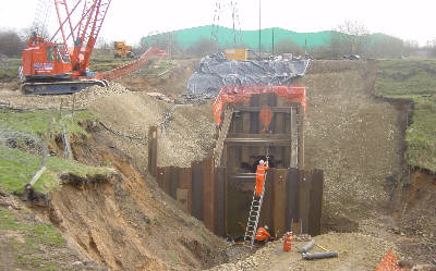
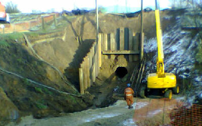
Photo: British Waterways
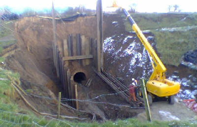
Photo: British Waterways
The Whit Brook, which flows through a culvert below the canal a short distance from Lock 59, was swollen following heavy rainfall. The volume of water caused the downstream end of the culvert to collapse, with about 1000 tonnes of the embankment slipping down into the brook. Engineers initially stated that the canal would be closed for at least four weeks, as work could not proceed until tests on the stability of the bank had taken place. However, due to the legal issues of access mentioned below, this was delayed.
The slippage was discovered early on 19th August. Because of the risk that the canal might breach it was immediately closed to navigation and the pound was partially drained. The towpath was also closed. Stop planks were used to allow a low level of water to remain in the half mile pound to protect the fish and other wildlife.
Below the surface layer of soil the embankment is built of sand. This made the embankment highly unstable. BW staff covered the exposed sand with plastic sheeting to prevent rain washing more away. The edge of the slippage was around 6 feet from the edge of the canal.
According to British Waterways, the culvert and the land around are not in the ownership of the Waterways Trust (owners of the canal) and the landowner apparently prevented British Waterways' engineers from completing ground investigations. The major work to re-instate the embankment could not be carried out until access to the site had been secured in October. The delays meant that there was no chance of the canal being re-opened during the 2004 boating season.
BW staff have appealed to the public to keep away from the site as the ground is dangerously unstable and at risk of further collapse.
BW suggested that boaters use the winding points at Oldham Broadway Bridge, below Lock 64, coming from Manchester, or below Lock 50 (Rochdale), coming from Littleborough (although it is also possible for boats to wind below the new Lock 53). In practice, few boats are likely to want to venture east from Manchester or West from Littleborough Summit until the canal re-opens.
Any boaters who were planning to travel on the Rochdale Canal should phone the Waterway Office on 01925 847 700 to get the latest information about this stoppage.
The following photographs were taken by British Waterways staff when they arrived at the scene:
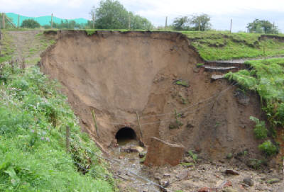
Photo: British Waterways
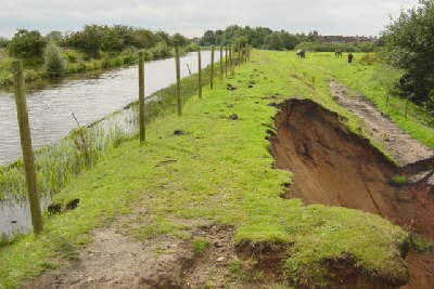
Photo: British Waterways
Bugsworth Basin set to re-open
March 22nd 2005
Bugsworth Basin is finally due to be re-opened at Easter 2005! The official opening is planned for 26th March 2005, when a boat rally will take place. Mooring over the Easter Weekend is only available to boats booked in for the rally.
Work to fix the major leak at Bugsworth Basin at the end of the Peak Forest Canal was completed in the summer of 2004. However, the basin complex was not re-opened at that time as dredging work still had to be carried out on the entrance canal.
Then, in September 2004 a leak developed on the entrance canal leading to the basins but swift action by British Waterways staff resulted in the leak being fixed before any harm was done. BW looked at the possibility of carrying out further work to improve the stability of the embankment. Early in 2005, the canal along this section was given a waterproff lining and the wash wall was re-built.
Major leaks have kept the basin complex closed since shortly after its re-opening in 1999. A new habitat was built for voles that were displaced by the repair work and a clay bund was built to keep the work area dry during the course of the work. Special access tracks were constructed of crushed limestone laid on "Terram" to protect the archaeologically important site from damage by contractors' vehicles.
See report and photos of the re-opening of Bugsworth Basin!
For more information, see www.brocross.com/iwps (external link opens in new window)